

You need to agree to share your Hugging Face information to access this dataset
This repository is publicly accessible, but you have to accept the conditions to access its files and content.
These data are free for education, training and research under CC BY-NC-SA 4.0. Direct commercial use is not permitted.
Log in or Sign Up to review the conditions and access this dataset content.
3D Grid on Reinforced Concrete: Rebar Mesh and Diagonal Electrical Cable
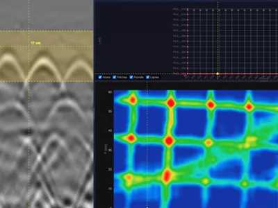
GPRbase ds021. Raw Ground Penetrating Radar (GPR) field data recorded with a GSSI 2700 MHz system on a reinforced concrete slab: a 3D grid of 38 profiles over a 1.2 × 0.6 m area. The data are free to use for education, training and research under CC BY-NC-SA 4.0.
Why this dataset is useful
The slab contains a reinforcement mesh and an electrical cable that crosses the survey area diagonally. On a single 2D profile the cable produces a hyperbola that looks like a rebar. Its angle only becomes visible on the horizontal time slices built from the full 3D grid. The dataset is therefore suited to practicing 3D grid interpretation and time-slice reading, and to learning how to tell an embedded service from reinforcement before drilling or coring.
At a glance
| Field | Value |
|---|---|
| GPRbase ID | ds021 |
| Applications | Concrete and civil engineering, embedded utilities |
| Technique | Ground Penetrating Radar |
| System | GSSI StructureScan Mini XT/LXT |
| Center frequency | 2700 MHz |
| Channels | 1 |
| Survey layout | 3D grid, 1.2 × 0.6 m, 38 profiles, 0.05 m line spacing |
| Targets | Rebar mesh, electrical cable, embedded service |
| Data type | Raw, unprocessed |
| Format | GSSI .DZT, each with its .DZX sidecar file |
| Files | 38 profiles (38 .DZT + 38 .DZX) and profiles.csv, about 30 MB in total |
| GPS | Not available |
| Ground truth | Partial, by electromagnetic (EM) detection |
| Contributor | MDSLab (MDS – Le Matériel de Sondage, France) |
| Published on GPRbase | 2026-08-17 |
| License | CC BY-NC-SA 4.0 |
What is included, and what is not
- The files are native GSSI recordings, exactly as acquired. No gain, filtering, migration or background removal has been applied.
- Each
.DZTfile comes with its.DZXfile, the XML sidecar written by the GSSI system alongside the radar data. - Acquisition settings (samples per scan, scans per meter, time range, dielectric constant) are stored in the header of each
.DZTfile. data/profiles.csvgives the position and direction of every profile on the grid.- There are no annotations, labels or train/test splits. This is documented field data, not a machine learning benchmark.
- Ground truth is partial. It comes from electromagnetic (EM) detection and does not describe every reflector in the slab.
Repository structure
ds021-3d-grid-reinforced-concrete/
├── README.md
└── data/
    ├── profiles.csv
    ├── FILE__001.DZT
    ├── FILE__001.DZX
    ├── ...
    ├── FILE__038.DZT
    └── FILE__038.DZX
Grid geometry and coordinate system
The 38 profiles were acquired over a 1.20 m × 0.60 m area of reinforced concrete, on a regular orthogonal grid with 0.05 m line spacing.
Coordinate reference
- Origin (0, 0): bottom-left corner of the grid, viewed from above.
- X axis: positive from left to right.
- Y axis: positive from bottom to top.
- Units: meters.
Horizontal profiles 001 to 013
The 13 horizontal profiles were acquired from left to right (+X direction). Each one extends from X = 0.00 m to X = 1.20 m.
- Profile 001: Y = 0.00 m
- Profile 002: Y = 0.05 m
- Profile 003: Y = 0.10 m
- ...
- Profile 013: Y = 0.60 m
Position formula: Y = (profile_number - 1) × 0.05 m
Vertical profiles 014 to 038
The 25 vertical profiles were acquired from bottom to top (+Y direction), progressing from left to right across the grid. Each one extends from Y = 0.00 m to Y = 0.60 m.
- Profile 014: X = 0.00 m
- Profile 015: X = 0.05 m
- Profile 016: X = 0.10 m
- ...
- Profile 038: X = 1.20 m
Position formula: X = (profile_number - 14) × 0.05 m
File naming
Each profile is a pair of GSSI files:
FILE__001.DZT/FILE__001.DZXtoFILE__013.DZT/FILE__013.DZX: horizontal profiles.FILE__014.DZT/FILE__014.DZXtoFILE__038.DZT/FILE__038.DZX: vertical profiles.
Geometry table: data/profiles.csv
One row per profile, with these columns:
| Column | Content |
|---|---|
profile_id |
Profile number, 001 to 038 |
dzt_file, dzx_file |
File names of the profile |
orientation |
horizontal or vertical |
x_start_m, y_start_m |
Start of the profile, in meters |
x_end_m, y_end_m |
End of the profile, in meters |
The scan direction runs from the start point to the end point. These coordinates describe the acquisition lines. They are not ground-truth annotations of the objects in the slab.
How to use
View without installing anything
Open the .DZT files in GPRviewer, a browser-based DZT viewer with a free tier. Disclosure: GPRviewer is published by MDS, which also maintains GPRbase. The files are standard GSSI files and also open in GSSI RADAN and in third-party tools that read the DZT format.
Download with Python
import csv
from pathlib import Path
from huggingface_hub import snapshot_download

REPO_ID = "gprbase/ds021-3d-grid-reinforced-concrete"

local_dir = snapshot_download(repo_id=REPO_ID, repo_type="dataset")
data_dir = Path(local_dir, "data")

files = sorted(p for p in data_dir.iterdir() if p.suffix.lower() == ".dzt")
print(len(files), "profiles")

with open(data_dir / "profiles.csv", newline="") as f:
    profiles = list(csv.DictReader(f))
first = profiles[0]
print(first["dzt_file"], first["orientation"], "from",
      (first["x_start_m"], first["y_start_m"]), "to", (first["x_end_m"], first["y_end_m"]))
Read a profile as a NumPy array
This example uses readgssi (MIT license, pip install readgssi).
from readgssi import readgssi

header, arrays, gps = readgssi.readgssi(infile=str(files[0]), antfreq=[2700], plotting=False)
bscan = arrays[0]  # shape: (samples, traces)
print(bscan.shape, header["rhf_range"], "ns,", header["rhf_spm"], "scans per meter")
Intended uses
- Teaching and self-training in radargram interpretation on concrete.
- Building and reading time slices from a 3D grid.
- Testing processing chains on real, unprocessed data: time-zero correction, background removal, gain, migration.
- Exploratory signal processing or machine learning work, provided you create your own labels.
Direct commercial use is not permitted by the license. Use in a professional context such as internal training or applied research is permitted.
License and attribution
The data are distributed under the Creative Commons Attribution-NonCommercial-ShareAlike 4.0 International license. If you modify or adapt the data, you must distribute your contribution under the same license.
Required attribution:
Source : GPRbase (https://www.gprbase.com) - Licence CC BY-NC-SA 4.0
For questions about the license or to request a specific permission, write to info@gprbase.com.
Citation
To cite this dataset:
@misc{gprbase_ds021,
  author       = {{MDS - Le Matériel de Sondage - GPRbase}},
  title        = {3D Grid on Reinforced Concrete — Rebar Mesh and Diagonal Electrical Cable},
  year         = {2026},
  publisher    = {GPRbase},
  howpublished = {\url{https://www.gprbase.com/en/dataset/ds021-3d-grid-on-reinforced-concrete-rebar-mesh-and-diagonal/}},
  note         = {GSSI, StructureScan Mini XT/LXT, 2700 MHz. Licensed under CC BY-NC-SA 4.0}
}
To cite GPRbase as a whole:
@misc{xavier_2026_gprbase,
  author    = {Xavier, J.},
  title     = {GPRBase: A Free Library of Real-World Ground Penetrating Radar Datasets for Education, Training and Research},
  year      = {2026},
  publisher = {Zenodo},
  doi       = {10.5281/zenodo.21894932},
  url       = {https://doi.org/10.5281/zenodo.21894932}
}
Links
- Dataset page (English): https://www.gprbase.com/en/dataset/ds021-3d-grid-on-reinforced-concrete-rebar-mesh-and-diagonal/
- Dataset page (French): https://www.gprbase.com/dataset/ds021-grille-3d-sur-beton-arme-ferraillage-et-cable-electrique-en/
- Machine-readable record: https://www.gprbase.com/api/datasets/ds021.json
- GPRbase, the full library: https://www.gprbase.com
- GPRbase community on Zenodo: https://zenodo.org/communities/gprbase
En français
Grille 3D sur béton armé — Ferraillage et câble électrique en diagonale. Données géoradar brutes (GSSI, 2700 MHz, format .DZT) acquises sur une dalle en béton armé : grille 3D de 38 profils au pas de 5 cm sur une zone de 1,2 × 0,6 m. Sur un profil 2D isolé, le câble électrique ressemble à une hyperbole d'armature. Seules les coupes horizontales issues de la grille 3D révèlent son tracé en diagonale. Le fichier data/profiles.csv donne la position et le sens de chaque profil. Données gratuites pour l'enseignement, la formation et la recherche, sous licence CC BY-NC-SA 4.0. Fiche complète : https://www.gprbase.com/dataset/ds021-grille-3d-sur-beton-arme-ferraillage-et-cable-electrique-en/
- Downloads last month
- 86